


PEORIA, Ill. (WMBD) — After a relatively quiet stretch of weather, a more active pattern will bring the threat of severe storms through midweek.
Key Takeaways:
- Rounds of storms possible Tuesday afternoon through Wednesday
- Damaging wind and large hail are the greatest threats
Tuesday
The NOAA Storm Prediction Center has the area in a level 1 out of 5 (marginal) severe risk for Tuesday. This outlook is valid from 7 a.m. Tuesday all the way to 7 a.m. Wednesday. It is possible to see this upgraded in future updates for portions of the area.

The morning hours are expected to be quiet, but storm chances will develop during the afternoon and evening. Coverage, location, and exact timing remains uncertain. Leftover energy from overnight storms to our west could enhance our storm potential Tuesday afternoon and evening, but confidence remains low.
Normal Community beats Brother Rice for third place-00:00
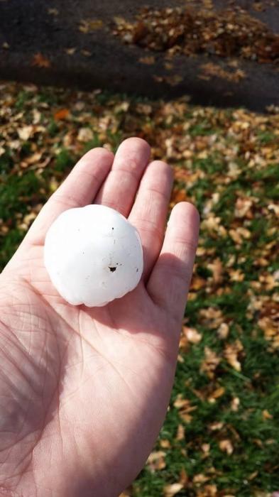
In general, it appears the greatest storm chance will set up near a frontal boundary across northern Illinois to around Interstate 80. It is possible to see some of these drift further south to impact the local area as we work into the evening. Damaging wind gusts and large hail will be the greatest threats.

Tuesday Night
Depending on how storms evolve Tuesday afternoon and evening, the stage could be set for another round moving into Central Illinois late Tuesday night into Wednesday morning. A decaying MCV moving out of Iowa and Missouri late Tuesday could spark another line or clusters of thunderstorms after midnight and into the Wednesday morning commute.
If storms do form and hold together they would be capable of producing damaging wind gusts and large hail. The tornado threat is low with this round of activity but brief spin-ups along the line are possible.
The most likely timeframe for storms to impact Central Illinois would be between 1 to 6 a.m.

Wednesday
The Storm Prediction Center has most of the area in a level 2 out of 5 (slight) severe threat. At this time, damaging wind gusts and large hail are the primary hazards. An isolated tornado or two can’t be ruled out.

Another line of severe thunderstorms appears possible Wednesday afternoon when a cold front pushes through Central Illinois. Any discrete storms that develop ahead of the main line could be capable of all severe hazards including large hail, damaging wind, and tornadoes.
Along the line damaging straight-line winds and some hail would be the main threats but isolated tornadoes would be possible. Currently, the area most favored for this round of storms looks to be along and east of Interstate 55 with storms developing Wednesday afternoon. Aside from the severe weather threats, localized flash flooding will also be possible, especially in areas that see repeated rounds of storms.

This forecast is evolving and will change between now and Tuesday. Now is a good time to review your severe weather preparedness plan, and be sure to have multiple ways to receive watches and warnings should they be issued.
Download the CIProud2Go Weather app for alerts tailored to your specific location, and be sure to follow Your Local Weather Authority on WMBD/WYZZ-TV and over social media live streams should severe weather threaten.