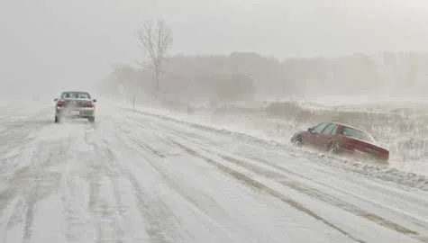
Snow challenged local motorists during a very white winter of 2014. (WJBC file photo)
By Joe Ragusa
NORMAL – It was both an average year and a record-setting year in central Illinois weather.
Normal saw 51.5 inches of snow in 2014 up through the last week of December, the second-highest total ever.
WMBD 31 Chief Meteorologist Marcus Bailey said the snow was spread out over the first few months of the year, and the weather pattern that dominated the first part of the year began late last year.
"You have the severe weather outbreak on Nov. 17, and following that, we started to get into a pretty cold spell where it was almost weekly from that point through most of the winter that we would have waves of snow coming in followed by a relentless push of arctic air," Bailey said.
Bailey said there we many daily overnight lows set this year. The coldest temperature recorded in central Illinois was -24 degrees on February 11th in Altona, just outside of Galesburg.
Spring in central Illinois was pretty quiet as far as severe weather is concerned.
Bailey says that was an EF-0 tornado that barely touched the ground in McLean and Woodford County. Temperatures were below average, as was the rainfall, and Bailey says that's because the winter weather pattern lasted into April.
Summer in central Illinois was also cooler than normal, but we did see more rain. Bailey says many towns in central Illinois saw rainfail amounts that ranked in the top-10 all time, but McLean County was largely spared from flash floods.
Overall, precipitation is about average this year due to a relatively dry spring and average fall. Overall temperatures are around average as well, with the hottest temperature recorded at 97 degrees in Normal Aug. 26.
Joe Ragusa can be reached at joe.ragusa@cumulus.com.