By Chris Yates (WMBD-TV)
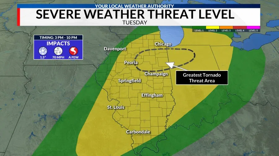
PEORIA – A strong storm system is expected to drag a cold front through Central Illinois Tuesday night triggering strong to severe thunderstorms from the Ozarks to the Great Lakes. The Storm Prediction Center has placed Central Illinois within a Level 2 Risk (Slight Risk) for severe storms.
Key Takeaways
- Severe storms are possible area wide
- Storm chances are highest along and east of the Illinois River
- All severe hazards are possible
- Large hail up to 1.50″ in diameter
- Damaging winds up to 70 mph
- A few tornadoes
- Sharp drop in temperatures Tuesday night, some snow possible
Severe Storm Set-up
Ahead of the incoming cold front, strong southerly winds will bring an unseasonably warm and moist air mass to Central Illinois with high temperatures warming into the lower 70s and dew points reaching the upper 50s and lower 60s. It’s an environment that is more common in April rather than February and one that will lead to enough instability for storms to develop.
Factor in a strong jet stream overhead and a strong cold front pushing in from the west, you’ve got all the ingredients in place for severe storms. Now it comes down to the “when and where” and this is where things get a little technical.
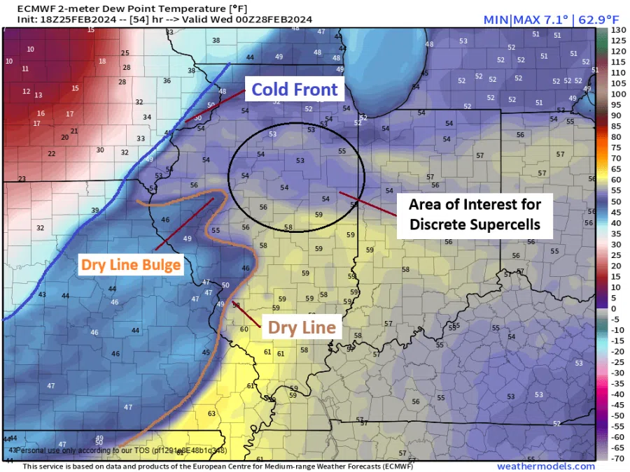
Model guidance is also showing something that’s relatively rare for Illinois, a dry line. A dry line is the boundary that separates the moist air from the Gulf of Mexico from the drier air that comes from the desert in our southwestern states. These are more common over the Central Plains in the Spring and Summer months. Rarely does one develop over Illinois, let alone in February!
While there are some differences, model guidance appears to be homing in on setting this dry line up near the Illinois River Tuesday afternoon. If convergence along the boundary is strong enough, discrete supercells capable of all hazards could develop a few hours before the cold front arrives. If the convergence is weaker and storms are kept at bay, storms wouldn’t develop until the cold front arrived early in the evening resulting in a squall-line where damaging winds will be the primary threat.
Interestingly, models even show a dry line bulge developing. This is where a wedge of dry air starts to advance eastward faster than the rest of the dry line. Severe weather potential is often increased ahead of this feature which puts areas along and east of the Illinois River in the firing zone.
Storm timing – 3 pm to 10 pm Tuesday
The current forecast calls for dry conditions Tuesday morning and early afternoon with isolated to widely scattered thunderstorms becoming possible by 3 pm. My thoughts are that these cells could develop near the Illinois River before moving east at 20-30 mph with all severe hazards possible. These storms will likely then start to evolve into a squall line as they cross I-55 and the cold front catches up to them between 9 pm and midnight.
Turning colder with some snow
Scattered showers will likely continue behind the cold front with gusty northwesterly winds bringing much colder air to the region. As colder temperatures filter in, rain should mix and change to snow after midnight allowing up to a half inch of snow to accumulate on grassy and elevated surfaces by sunrise. Temperatures Wednesday morning will likely be in the low to mid 20s with wind chills in the teens. Highs will only reach the lower 30s.
WMBD-TV can be reached at news@wjbc.com.